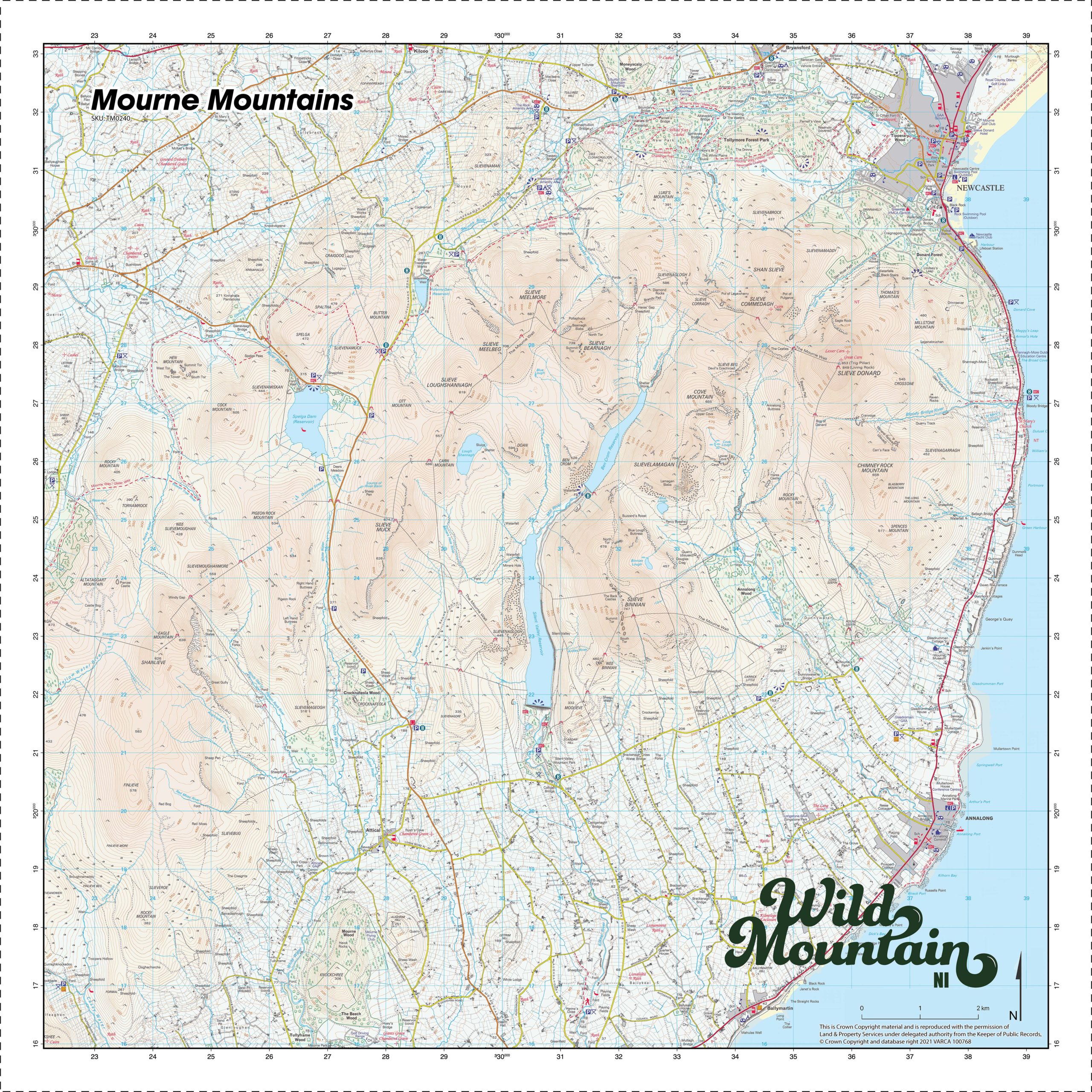
Description
The Mourne Mountains Map SplashMap is a result of our partnership with mountain leaders from Wild Mountain NI and has been expertly positioned to take in the best of this beautiful, rugged and internationally recognisible landscape. See how we arrived at this awesome product together here.
About the Mourne Mountains
The Mourne Mountains (/mɔːrn/ MORN; Irish: Beanna Boirche) is a granite mountain range in County Down in the south-east of Northern Ireland. The Mourne Mountain Map includes the highest (850m) of the mountains, Slieve Donard. It’s an Area of Outstanding Natural Beauty but, perhaps thanks in part to its recent popularity, there are moves afoot to make the area Northern Ireland’s first national park. The area, part owned by the National Trust, receives visitors from all over the world thanks to recent films and series featuring its dramatic character (e.g. Game of Thrones).
The Mourne Wall
The iconic Mourne Wall (Irish: Balla an Mhúrn) was constructed to enclose a catchment area of the Silent Valley and Ben Crom reservoirs. It’s a 1.5 metres (4 ft 11 in) high stone wall originally built to keep livestock from contaminating water supplies. It took almost twenty years to complete (1904 to 1922). Hiking the Mourne wall is a famed walking challenge, taking in 15 summits on its 22 mile route. This hike is not for the faint hearted but will reward you with some of the best views in the mountain range.
The Brandy Pad
The Brandy Pad is one of the many beautiful walks through the Mournes. Named the ‘Brandy Pad’ because it was the old smuggling route, it runs from “Bloody Bridge” up through the mountains of Mourne, through the “Hare’s Gap” and into the heart of County Down. Brandy, wine, tobacco, tea and silk are all believed to have been smuggled along this route to avoid taxes.
KEY INFORMATION:
Major Settlements / Features:
Mourne Wall, Silent Valley Reservoir, Ben Crom Reservoir, Spelga Dam, Devil’s Coach Road, Slieve Donard, 7 Sevens, Brandy Pad, Trassey Track, Hare’s Gap, Windy Gap, Pot of Legawherrty, Ice House, Hare’s Castle, Meelmore Lodge Camp & Amenity Site, Carrick Cottage Café, Mourne Shuttle Service,
National Grid Coordinates (Easting, Northing / Grid Reference):
Lower-left – [LL]
Upper-right – [UR]
Scale:
1:25,000
Size of product (including borders):
72cm x 72cm (approximately)
Only logged in customers who have purchased this product may leave a review.


Reviews
There are no reviews yet.