SplashMaps are proud co-sponsors of a gathering called #Geomob. Every 2 months we gain from the insights and we support the new and emergent technologies that come from the vibrant geo technology sector in this country. It’s quickly becoming the go-to place for guidance & inspiration on growing a innovative business that involves “place”.
For me, working in the geo industries has always been an inspirational way to look into the future. Deep into the future! It’s great to see the mob attract a broader base too! From its OpenStreetMap core the group now attracts big business and yesterday it was encouraging to see geo folk from Shell, Hexagon and ESRI rubbing shoulders and testing the waters with our start-up guests. Of all the geo-networks this is the most relaxed yet vibrant, fresh, somewhat unforgiving, edgy and yet business orientated of the networks we get in the UK. And there’s free #geobeer at the end of each one!
Our packed gathering of the nations georaty (at the spacious Traveltech lab) came as a welcome break from some particularly hard data crunching and reporting I’m doing for the European Commission en-route to finalising my report on the Next Generation Internet.
But really, as breaks go, this took me even deeper into the conundrum of the connected world’s issues. The excellent talks reminded me of the almost bipolar role of geography; when it comes to privacy it is the most contentious of technologies, yet when applied cleverly it enables the most compelling applications on the planet! I feel like I’ve defracted between these two forces. I want the tech, but I don’t want the inevitable consequences.
So yesterday I stayed in uncharacteristic silence though every talk and for once let everyone else ask the questions.
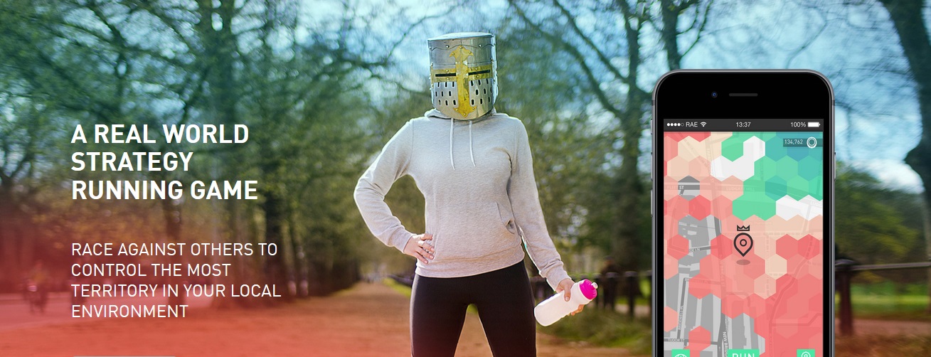
Sam Hill presented his strategy, land grabbing running game,” Run an Empire“. As he said it’s a sort of fitness tracker meets game (or even Strava meets Game of Thrones!). He’d spotted that running apps are all about a self obsession with monitoring and have little to do with engaging in communities and even less about play. Many of us need a motivation beyond the rightful feeling of slicing a second off our best time.
Set off on your run and claim the territory you pass through. Maintain that territory against rivals by going again and again posting better and better times. Already available on the iPhone, Sam insists this is about Games and not gamification. In other words it’s not rewarding with ticks in boxes, but instead your sense of play and competition against others should leave you with that good old board game elation when you see your opponents crumble (not sure if I got that right?).
But what are we doing here? The app zones up a space into hexagons and so the location is somewhat arbitrary, but it still relates to your location at a given time. The app is engaging and the business is going to be a success (according to an impressive list of press it already is).
For a long time exercise has been a bit… well boring! Now it’s fun! But you are tracked! The data is held. It is viewed by others and a lot of time spent in one place will show up like a medieval flag struck into the earth! That’s actually both the intention and the risk. In the ideal concepts of personal data spaces this information would be sacred, anonymised and non-crossreferencable. But let’s be realistic. We’ll all love this game. Businesses will love it too and before we know it the boxes we tick to download the app will be in the hands of much bigger organisations than “Run an Empire”. How can this personal data be kept secure from abuse by businesses and cyber criminals?
I loved it, and so did the guys at Geomob, after-all it came second in the SplashMaps “vote for the best presentation” award. I aspire to take over my home town in the next few weeks and damn the consequences (for now!).
The project was initially Seed funded via Ordnance Survey’s Geovation. This initiative from the OS spawned two of the most focussed projects of the evening, both gaining high accolades and a credit to the initiatives creators, Chris Parker and Alex Wrotessey and their teams.
Sam’s a designer of apps and not a classic geographer or qualified geonerd. So when he asked for help in taking his hexagonal grid based on a flat earth model and extending it to our odd shaped planet, Jeremy Morley, Chief Geospatial Scientist at Ordnance Survey – a regular – was able to guide him to the research that’ll help his global roll-out.
Mike’s was a compelling presentation – a personal project obsession on the verge of becoming a business. So I guess I can sympathise strongly with Mike.
Professing his presentation to be probably the “most middle-class” geo project ever to appear to go before the geomob he told a story of a half created app which suddenly and covertly got picked-up by his local estate agent.
Making an algorithm around the school catchment areas in this country is hard but valued work. Most of the time working backwards from the pdf documents found on line and often following fruitless meetings with authorities around the country, Mike eventually managed to boil down the catchment system of at least 4 counties into a bunch of algorithms and a neat app aimed at home buyers. So now you don’t have to rely upon the exaggerated claims of the owner and the estate agent to do your initial background research.
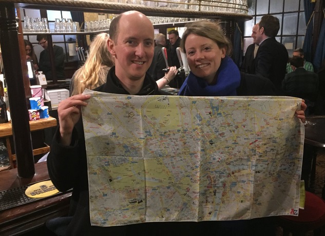
The anomalies and the persistence in making the perfect catchment took chimed well with a conscientious, but often difficult to please audience, and Mike was rewarded with first prize; The highly prized AtoZ SplashMap of London.
How can it be improved? Mobsters were on hand afterwards to help Mike on his way to a proper business model to roll-out through the land.
One days drones will do most of the stuff for us and do it quicker. But like everything else in the world they’re bound to run into trouble! And if you run into trouble you’d better have an insurance policy.
Ed from Flock presented a now very commercial advance on a project started at Imperial College London. It’s now another of Geovation’s success stories.
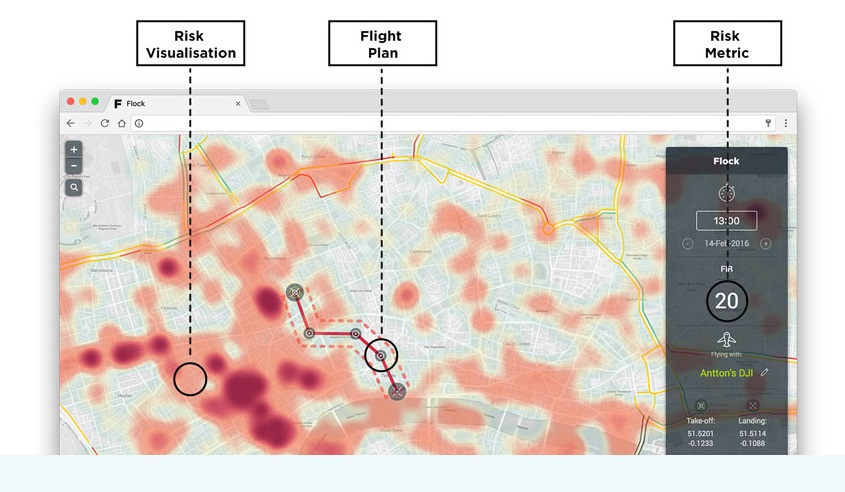
Flock enables pay-as-you-go insurance policies for those that fly drones! It’s a win:win for all concerned. The user only pays insurance when it’s needed, the insurers end up with a 360 degree view of what really happened when the drone hit the fan, and the aircraft, people and infrastructure that are in the flight-path can rest assured that their reimbursement will be minimised by a well informed loss adjuster.
Flock crunch the data they hold for all the infrastructure and temporal information they have in the chosen area of the drone flight. So if you fly-out over London the buildings and street furniture are all potential hazards, but also the time of day and the day of the week may determine how many people are milling around too! In this way Flock can assess the risk for any flight path chosen at any time. Further they can even encourage you toward better times of day and better flight paths to achieve your objecitve via the lowest risk route!
Brilliantly conceived and fabulously executed. The app looks beautiful and useful. But most importantly Flock already have the insurance companies lined up and are grabbing a lot of PR attention. There is true business savvy behind it. More impressive still is Ed’s future vision, captured even in the business name. In the future more and more will be done by these quad-copter work-horses. And pretty soon they will be automated. A flock of drones definitely needs insurance, but more importantly they need to make decisions for themselves based upon real time data, including real-time hazard data.
But just remember the potential for this autonomous technology when you can be singled out from the data. A parcel could be delivered “risk-free” straight to you as you stride; but do you dare to open it and check-out what’s inside?
This is definately a business to watch.
Putting aside the honour of facing the imposing intellect of the geomob and the clamour to own the latest SplashMap, what else do people gain from presenting at GeoMob?
But for all it was really a chance to put the idea out there and see what happens; to take-on the pressure of the pitch and gain some votes.
And for geomobsters? It’s about connecting with a great community, understanding the future of “place”, catching up and making things happen. Join us at the next one!
