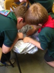
They won our our best scouting cartographer competition! Now they’ve completed their navigation stage 2 badge with SplashMaps!
The Chandler’s Ford 15th Cubs loved the SplashMaps which we put through their paces. By the end all the maps were gloriously covered in felt tips lines, floor grot and general boy-grub.
What’s in the Navigation stage 2 badge? Well our recipe was as below and any scout leader is welcome to use it;
Navigator – stage 2
How to earn your badge
a) Group: Find the key on your SplashMap, can you describe what they are?
b) Group: Can you find examples of them on the map?
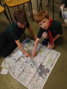
2. Learn how to read a four-figure grid reference.
a) Small teams: Can you find an example of one of the symbols on the map? (campsite, car park or church for example)
b) Instructor; 4 figure grid reference.
i) How each location in Great Britain is unique and can be identified by a unique grid reference number.
ii) Along the corridor and up the stairs principle of coordinate reading
iii)Numbering to the bottom left corner of the square
c) Small teams; can you give us the grid reference of the square in which the symbol is found?
d) Instructor; demonstrate to all teams how they did this
e) Instructor; Where within the square is the symbol; again along the corridor and up the stairs with imaginary 10 grids within the square.
3. Use a map during an outdoor activity.

4. Draw a simple map to direct someone from your meeting place to a local point of interest.
Instructor: Distribute pens (washable felt tips), explain this is only possible on certain maps and get permission from the map owner.
Small teams make best route from here to the symbol chosen above.
a) Make written instructions of how to get there using the features on the map.
b) What kind of road signs would you see to help guide people
c) What other features would you use that you find on the map?
5. With other Scouts, go for a walk with a leader around the local area. Take it in turns to use one of these methods of navigation:
written instructions
recorded instructions
road signs
tracking signs
maps.
6. Learn the eight points of a compass and use them in an activity.
a) Instructor distribute compasses, ask the cubs (small groups on each map) to hold their compass against the map and find the North Arrow. Align with the grid.
b) Demonstrate the grid with relation to the North Arrow, for Grid North, explain there is a difference with Magnetic North, but (at this stage) it is not being tested.
c) Test on the knowledge of N, E, S, W and any pneumonics they many know.
d) Ask if anyone knows how you describe the gaps between these. (Use examples on the map).
e) Explain NE, NW etc.
f) Find a new feature on the map and use the 8 points of the compass to describe where the destination is relative to your location.
7. Show you know how to dress appropriately for the activities involved in this badge and what equipment you and the adults need on the activities.
Of course a SplashMap neckwarmer or pro map should be part of this final
