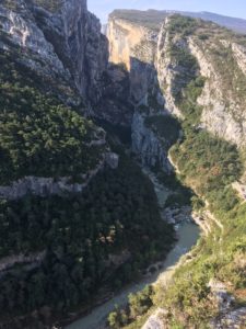
As a test of my family’s tolerance, my stamina and a SplashMaps’ usefulness when Mountain Biking Anywhere, we booked a 13 day stay at the bottom of Europe’s deepest canyon, the Gorge du Verdon.
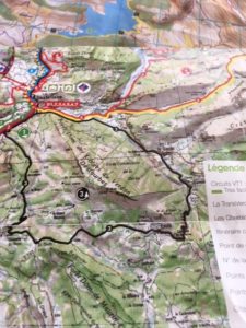
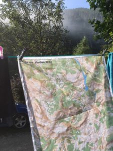
I set-up a personalised SplashMap at 1:40 000 to cover all the main trails centred on our local town using the simple make-a-map service here. Set-up in mid-July, it’d been tempting me with its tight contours for weeks!
Assuring as few distractions as possible, our campsite offered the feeblest of WiFi’s on the thinnest of broadbands with a back-up of only one bar phone signal when the weather permitted. Coupled with almost guaranteed daily thunderstorms (10 days of the 13) this break offered as few distractions as we dared (when entertaining 4 kids between the ages of 7 and 15). A beautiful and perfect family holiday destination!

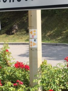
Finding the trails isn’t hard. Castellane was the nearest Tourist Info centre to our base. From there you can spend Euro3 on a folded paper IGN map of the circular mountainbike trails. Each trail is heavily marked and graded Green (very easy) to Black (tres difficile) with a profile and a brief description on the reverse. Corresponding route markers were liberally scattered across the mountains and passes.
So, navigating the trails was easy right? Wrong! Despite the route markers and the dedicated maps, a bunch of things contributed to uncertainty en-route. Firstly, the clear IGN line-work that would normally depict routes and types of trail was obscured by the heavy black, red, blue and green routes marked on the map. This meant you were never aware of when you should expect tarmac, broad trail or single-track trails. Secondly, though well maintained in most places, the trail markers appeared to fade quickly in the sun so that numbers and arrows were no longer visible. As is always the case a few missing or misleading trail markers show how important map reading can be.
We started with the Blue and shorter red trails to find our way around. Blue, designated “easy”, was a great demonstration of how perception changes when Mountain Biking Anywhere. We met British parents getting up a 13% blue slope with a gaggle of complaining sub-teen kids dragging their bikes behind. “Easy” is not for kids or occasional bike riders! It really translates as “easy …for a club rider”. Our position at the bottom of the valley meant there was only one way to go and it’s normally very steep and long! The Black epic route (62km in the end) circumnavigated the Castillion reservoir and involved an initial continuous climb of 1.5 hours to gain 700m at gradients between 7 and 14%. Literally ball-aching.
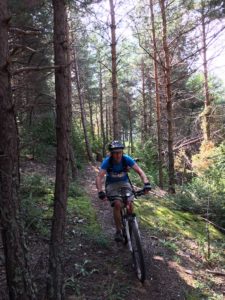
When Mountain Biking Anywhere, downhill is all about thrills. At the tops the echoing thunder often chased us around the precipitous single track. These were the best; sweeping, turning, rocky but handleable on my hard-tail Kona bike. But often the route would nose-dive us down impossibly steep tracks where occasionally it was even “forbidden” to ride. You can ascend these with more seamlessly with a dropper post for your saddle and your weight entirely back, perhaps fatter wheels too. But for my bike I was balanced too far forward and needed to port the bike on a couple of occasions. Time to invest?
Riding with uber-fit brother-in-law, Jonathan – he’d just returned from the Ride London 100 as the first veteran to cross the line with cow-horn handlebars – keeping a pace was a challenge, but the rhythm and the cadence soon take-over and despite my small wheels I was pleased with my climbs. However, pressing-on too hard with not enough food (and perhaps some holiday excess the night before) meant I was spent when commencing the second 500m climb of the epic. I left Jonathan to complete the circuit (naturally the first thing he got was lost once his map man was off the trail).
The SplashMap came into its own, providing the essential detail. Clear contours and hill shading meant the climbing challenges were easily anticipated. I’d marked the route with a washable felt tip pen. This meant the trail detail was still totally visible, unlike on the locally purchased map. On the map there is clear differentiation between tarmac, unmade broad trail and single track, so you always know what’s coming. There’s even a red designation for trails intended specifically for bikes. And it was remarkable how often the clearly marked electricity pylons and cables gave assurance both of your position and the direction of the trail. As we’d seen at the Scott Mountain Marathon, it’s too easy to fall foul of poor or abused route markers. We stayed on track the whole time. Remember you can Mountain Bike Anywhere in the world with SplashMaps.
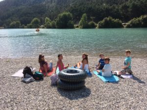
The rewards, being in France, were great. Delicious beer and coffee in pretty squares shaded by plane trees and refreshed with public fountains. These treat stops were great to get together with other family members and remember this is a holiday and not just a bike fest. Mountain Biking Anywhere in the world can be improved with a great map. But for mountain biking, the Gorge du Verdon has it all!
